


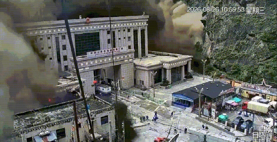
Update, August 27, 2026: This article’s warnings became reality this week. On the morning of August 26, 2026, a roughly 2,000-foot-wide section of glacier snapped off at around 17,000 feet on the Tibetan side of the Nepal-China border, triggering a debris flow down the Lhende River near Rasuwagadhi. The US Geological Survey confirmed the disaster was caused by glacial collapse, not the magnitude 4.4 seismic event initially blamed on an earthquake — that signal was later found to be the landslide itself, registering 5.2 on the Richter scale. As of this writing, Nepal Police have recovered 157 bodies, China has confirmed 3 deaths with 265 people missing in Gyirong, Tibet, and Nepal’s Tourism Board lists 384 travelers unaccounted for, including over 100 Indian nationals, 54 Americans, 34 Australians, and 33 Britons — many of them Kailash Mansarovar pilgrims. Experts now warn that debris still choking the river channel could trigger a second flood surge, actively complicating rescue efforts. Strikingly, this is the second catastrophic flood at this exact same spot on the Lhende River in just 14 months — a nearly identical glacial outburst destroyed the same Nepal-China Friendship Bridge in July 2025. Everything below explains why this keeps happening, and why almost nobody saw it coming in time.
Every monsoon season, the same headlines return: rivers bursting their banks, bridges washed away, villages cut off, and a rising death toll in Nepal. It can feel almost scripted — as if nothing has been learned from the last flood. But the truth is more complicated, and more urgent, than “Nepal doesn’t prepare.” The real story involves geography, glaciers, geopolitics, and a warming planet that is quietly rewriting the rules of what “monsoon season” even means in the Himalayas.
Here is a clear, science-based look at why Nepal floods, why they’re so hard to predict, why China’s role complicates things, and whether the human cost can actually be brought down.
Why Nepal Is So Flood-Prone: The Real, Scientific Reasons
Nepal isn’t unlucky — it’s geographically and climatically set up for exactly this kind of disaster, for several compounding reasons.
1. It sits in one of the steepest, youngest mountain ranges on Earth. The Himalayas are geologically young and still rising, which means the terrain is unstable, slopes are steep, and soil is loose. When heavy rain hits, water doesn’t soak in gradually — it rushes downhill fast, triggering landslides that dam rivers and then burst, multiplying the flood’s force.
2. The monsoon dumps extreme rainfall in a short window. Nepal receives the bulk of its annual rainfall between June and September. When a low-pressure system stalls over the region, it can drop months’ worth of rain in days — this is exactly what caused the catastrophic September 2024 Kathmandu floods, driven by the heaviest rainfall the region had recorded since 1970.
3. Glacial Lake Outburst Floods (GLOFs) are a growing, separate threat. High in the mountains, glaciers are melting and forming lakes — some held back by nothing sturdier than loose rock and ice debris. When these natural dams fail, they release enormous volumes of water in minutes, with no rainfall required at all. This is precisely what happened in July 2025, when a supraglacial lake — a lake that forms directly on the glacier’s surface — burst on the Nepal-China border, destroying the Nepal-China Friendship Bridge and killing at least nine people, with dozens more missing.
4. Unplanned urbanization has removed nature’s buffers. Kathmandu Valley’s rapid, poorly regulated growth has led to construction on floodplains and riverbanks — areas that once absorbed excess water now funnel it straight into homes and roads.
5. Climate change is intensifying all of the above. Warmer temperatures mean faster glacial melt (more GLOF risk), more erratic and intense rainfall, and less predictable monsoon behavior overall — a pattern scientists at the International Centre for Integrated Mountain Development (ICIMOD) describe as increasing at an “unprecedented” pace across the Hindu Kush Himalayan region.
Why Can’t We Predict These Floods Before They Happen?
This is the most painful question, and the honest answer is: it’s not for lack of trying — it’s because the physics and the geography work against early detection.
- The danger zones are remote and nearly inaccessible. Many high-risk glacial lakes sit above 5,000 meters, in terrain so difficult that even reaching them to install monitoring equipment is a major expedition.
- GLOFs can happen without warning signs a satellite catches in time. A supraglacial lake can grow rapidly over just weeks and burst with very little advance indication — the July 2025 lake that caused the Rasuwa disaster reportedly grew significantly in size in the month before it collapsed.
- Early warning systems exist, but are extremely limited. Nepal has deployed some GLOF early warning systems, but they cover only a fraction of the roughly 200+ glacial lakes across the Himalayan region now considered high-risk. Even where systems exist, experts note they may give communities only minutes to an hour of advance notice — barely enough to run, not enough to relocate infrastructure.
- Rainfall-driven floods are somewhat more predictable, but not precisely. Meteorologists can forecast that heavy monsoon rain is coming, but pinpointing exactly which river will breach, when, and by how much, in mountainous terrain with limited ground sensors, remains genuinely difficult.
In short: this isn’t a failure of effort. It’s a mismatch between how fast these events unfold and how much monitoring infrastructure current funding and terrain allow.
Why Doesn’t China Inform Nepal in Advance?
This question comes up after nearly every cross-border flood, and it deserves a direct answer: Nepal, unlike India, does not have a formal hydrological data-sharing agreement with China.
India signed a Memorandum of Understanding with China back in 2002 (renewed and expanded several times since) specifically requiring Beijing to share water-level and rainfall data from monitoring stations on the Brahmaputra and Sutlej rivers in Tibet, precisely to give downstream Indian states advance flood warning. Even that arrangement has been imperfect — China paused data-sharing during a 2017 border standoff, citing damaged equipment, and there have been recurring complaints from Indian officials about limited scope and delays.
Nepal has no equivalent agreement in place for its own trans-boundary rivers. Many of the glacial lakes that threaten Nepal — including the one responsible for the July 2025 disaster — sit inside Tibet, just north of the border, entirely within China’s territory and outside Nepal’s ability to monitor directly. Without a bilateral mechanism requiring China to share real-time glacial and hydrological data, Nepal is often left reconstructing what happened after the fact, using satellite imagery from regional bodies like ICIMOD, rather than receiving advance warning before the water arrives.
This isn’t necessarily a matter of China withholding information out of malice — supraglacial lakes are notoriously hard to monitor even for the country they’re located in, and China faces its own casualties and damage from these same events. But the absence of a structured, mandatory early-warning arrangement between the two countries — the kind India has fought for and partially secured — remains a real, fixable gap in Nepal’s flood preparedness.
Can Nepal Actually Reduce the Casualties?
Yes — and the good news is that the fixes are largely known. The challenge is funding, coordination, and speed of implementation.
- Expand glacial lake monitoring and early warning systems to cover more of the highest-risk lakes, not just a handful. Nepal has been a regional leader in deploying these systems, but scale remains the limiting factor.
- Pursue a formal data-sharing agreement with China, similar to India’s Brahmaputra MoU, specifically covering glacial lakes and rivers that originate in Tibet and threaten Nepali territory downstream.
- Enforce floodplain and riverbank construction restrictions in urban areas like Kathmandu Valley, where unplanned building has removed the land’s natural capacity to absorb floodwater.
- Invest in regional satellite-based monitoring through bodies like ICIMOD, which can detect changes in glacial lakes across borders regardless of which country controls the ground beneath them.
- Strengthen community-level evacuation planning in known high-risk river valleys, so that even a short warning window translates into lives saved rather than lost.
- Artificially lower water levels in the most dangerous lakes — a method already used successfully in Bhutan — to reduce the volume of water available to cause catastrophic damage if a lake does burst.
None of this eliminates the risk entirely — Nepal’s geography guarantees some level of flood danger will always exist. But the gap between “worst-case” and “manageable” casualty numbers is very much something policy, funding, and cross-border cooperation can influence.
Will Nepal See More Floods Like This in the Future?
Nearly every credible climate and glaciology assessment points the same direction: yes, and likely worse.
- Himalayan glaciers are melting faster as global temperatures rise, which means more — and larger — glacial lakes are forming, increasing GLOF risk across the region, not just in Nepal.
- Monsoon rainfall patterns are becoming more erratic and intense, a recognized signature of climate change in South Asia, meaning extreme rainfall events like the record-breaking 2024 Kathmandu floods may become less rare rather than more.
- More than 200 glacial lakes across the Himalayan region — spanning Nepal, India, Pakistan, Bhutan, and China — are now considered high-risk, and that number is expected to grow as glaciers continue retreating.
- Regional scientists describe the frequency of dangerous glacial events as increasing at an “unprecedented” pace, with researchers openly stating they need to better understand the cascading triggers behind these floods.
The takeaway isn’t fatalism — it’s urgency. The infrastructure, monitoring systems, and cross-border agreements that could meaningfully reduce casualties are buildable today. The window to build them before the next major flood is the real deadline.
This article draws on recent flood events, glaciological research, and reporting from Nepal’s Department of Hydrology and Meteorology, ICIMOD, and international news agencies.